
The very severe cyclonic storm Tauktae could cause heavy to very heavy rains at isolated places in north Konkan, Mumbai, Thane and Palghar in Maharashtra on May 17, the India Meteorological Department (IMD) said.

Authorities have sounded red alert in three districts of Kerala on May 14 and five districts on May 15, indicating the possibility of extremely heavy rains under the influence of a low pressure area over the Arabian Sea.

"The season averaged maximum temperatures in Himachal Pradesh, West Rajasthan, Konkan, Goa, Coastal Karnataka, Kerala and Arunachal Pradesh are likely to be higher than normal by 0.5-1.0 degree Celsius," the Met department has said in its forecast.

The mercury breached the 46-degree Celsius mark in several places such as Allahabad (46.8 degrees Celsius) and Jhansi (46.2 degrees Celsius) in Uttar Pradesh; Sports Complex (46.4 degrees Celsius) in Delhi; Ganganagar (46.4 degrees Celsius) in Rajasthan; Nowgong (46.2 degrees Celsius) in Madhya Pradesh; and Maharashtra's Chandrapur (46.4 degrees Celsius).

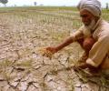
The news will augur well for the country as large parts have been witnessing agriculture distress and water levels in reservoirs in west and south India have dipped to low levels.

The India Meteorological Department said rainfall would be accompanied by gale wind speed reaching 140 to 150 kmph and gusting to 165 kmph along and off Odisha and north Andhra Pradesh coasts.

Riding high on the hopes of a normal monsoon, the agriculture ministry aims to increase foodgrain production by 6.35 million tonnes to a record 298.3 million tonnes in the 2020-21 crop year. The foodgrain output in the 2019-20 crop year (July-June) is estimated at an all-time high 291.95 million tonnes, as per the second advance estimates released by the ministry in February.

It has also predicted a below normal monsoon for the season with a Long Period Average of 93 per cent, subject to the error margin of 5 per cent.

22 bodies, 13 from Kottayam district and 9 from Idukki were recovered from various rain-hit areas while National Disaster Response Force teams continued their rescue operations.

According to an IMD forecast issued on Thursday, a heatwave spell will persist over northwest and central India during the next five days and over east India during the next three days.
'Each cyclone has its own identity and its own behaviour based on the environmental conditions in the ocean and in the atmosphere.'

The Indian Meteorological Department, meanwhile, warned of intense spell of 30 to 50 mm rainfall per hour with strong winds in Mumbai and suburban areas.

Rain may play spoilsport in the third and final T20 international between India and Australia with the weather forecast indicating possibility of light to moderate rain, in Hyderabad, on Friday.

'What's being predicted for Mumbai is not so different from what Kolkata experienced.' 'People should definitely be alert and aware and follow the advice of the disaster managers.'

Monsoons have had limited effect on market returns for a given year, report Sachin Mampatta and Sundar Sethuraman.

According to the IMD forecast, monsoon is likely to be normal this year.

Officials in the weather department said the monsoon is expected to be below normal because of the El-Nino effect.

This is the first time in the history of Jharkhand that it is facing such a severe cyclonic storm.

Organisers have been criticised by players attempting to make the main draw of the season opening Grand Slam for continuing to play matches despite the poor air quality from bushfires.

Speaking to reporters after visiting the flood-hit Bhadrachalam town in Bhadradri-Kothagudem district, Rao announced allocation of Rs 1,000 crore as a rehabilitation package for the temple town to build colonies in highlands for a permanent solution from flood threat.

IMD will present its month-wise and region-wise forecast in June.

Till Thursday, the country had received 41 per cent less June rainfall than normal -- the scantiest in a decade and one of the rarest occasions when the shortfall in the month was more than 30 per cent -- private weather forecaster Skymet said in its daily weather forecast on Friday.

All sub-regions have been receiving good rainfall except the North-east and east region of the country, where the deficiency has reached 23 per cent.

The forecast of deficient monsoon rainfalls scared farmers.
The India Meteorological Department's first monsoon forecast for this year would have gladdened many a heart with the hope of plentiful rain, after two drought years.
A private sector weather forecaster, Skymet, and some global forecasters have already issued warnings for this year that this could happen.

The mean maximum temperature for the month of March was 28.2 degrees Celsius in 2020 and 2019. It was 32.8 degrees Celsius in 2018; 30.7 degrees Celsius in 2017 and 31.5 degrees Celsius in 2016, according to the India Meteorological Department data.

The Central Railway has decided to operate its suburban services in Mumbai division on Sunday time table, which means it will ply fewer trains, compared to weekdays when trains are run in full capacity.

The forecast for better rains this seasons comes after India witnessed one of the worst droughts in recent times when the monsoon had failed last year.

The district administration has instructed tourists to postpone their visit to Dharamshala in view of the heavy rains.

The IMD said that there has been an increase in the rainfall activity in Kerala and monsoon could hit the state anytime now.
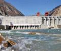
The government on Wednesday said any attempt by China to set up a hydropower station on the Brahmaputra river will act as an encroachment on the entitled rights of lower riparian states like India and Bangladesh and adversely affect the availability of water in its basin during the lean season.

According to Skymet Weather, the initial surge in the Monsoon rains can be attributed to the transition of El Nino into the neutral phase.

Expected to be over 100% of long average period.
With the weather forecast for Friday predicting another round of heavy rainfall, India will be the lucky team if it eventually pours, as they would then automatically advance to the final of the ICC World T20.

On Sunday, too, a drizzle resulted in an increase in humidity, triggering a massive pollution spike.

However, the areas under paddy - the biggest cereal grown during the kharif season - continue to be less than last year, mainly due to delayed onset of rains and also on account of shift towards the more lucrative maize.

The rains have so far been four per cent below normal.

The Centre will review the situation on a fortnightly basis.

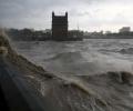
'Storms push a lot of water into land, then there is heavy rainfall due to the cyclone.' 'Along with this, we see the gradual rising of the sea level.' 'We see this during and after the latest Cyclone Tauktae.' 'This kind of overlapping events are increasing and we do not know much about how to tackle them.'